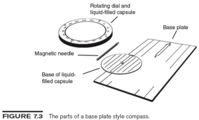
The best type of compass to use with a map has a transparent base plate with a straight edge on both sides (see figure 7.3). The edge of the base pate indicates the direction of travel. Some base plates have printed lines parallel to the edges with arrows indicating the direction of travel. The magnetic needle, usually red on the end indicating north and white or black on the end indicating south, is mounted in a circular liquid-filled housing. The liquid dampens vibration and increases accuracy and legibility. This housing rotates on the base plate and is surrounded by a dial marked with the cardinal directions and the degrees around the circle. An indicator or arrow is on the front of this dial and centered on the base plate. You read or set the bearing at this point. The rotating housing containing the magnetic needle also has a transparent base that is imprinted with the outline (usually in red) of an arrow.
You orient a compass either by rotating the housing on the base plate until the outline of the arrow on the bottom of the housing lines up with the north end of the magnetic needle or by holding the compass at waist height and level in front of you and rotating your body until the outline in the bottom of the housing is aligned with the north end of the magnetic needle. Although the principles for using any base plate style compass are the same, you should become familiar with the specific compass that you have and read the instructions provided by the manufacturer because models vary. Optional features may include a declination adjustment, a clinometer for measuring the steepness of slopes, or a sighting mirror.
Understanding Magnetic Declination
When you read north on a compass, you are really reading the direction of the magnetic field that points toward the magnetic north pole, which is about 800 miles (1,300 km) away from true geographic north. The powerful geomagnetic field that lies under the earth’s surface is generally aligned to north and south but does not run in a straight line from pole to pole. This magnetic field varies in a complex way over the surface of the earth and changes slowly over time. So your compass almost never points to true north.
The difference between true north and magnetic north is called declination. To be accurate in your navigation with a map and compass, you must factor declination into your bearings (see page 135). If you neglect to do this, you could miss your intended target by several miles or kilometers. A diagram at the bottom of maps shows the difference between magnetic north and true north (see figure 7.4). Magnetic north is indicated by MN, and true north is indicated by a star symbol. If the symbol for MN is located to the right of true north on the diagram, an east declination is present. In other words, the magnetic fields of the earth at the particular location that the map describes will cause the magnetized needle on a compass to pull beyond true north toward the east. If the symbol for MN is located to the left of true north on the diagram, a west declination is present. The declination diagram printed on the map is only a representation. Always use the number values rather than the printed directional lines when adjusting for declination.
The magnetic declination that appears on maps is computed when the map is made, so the declination factor provided may not be correct unless it is recent. To obtain current magnetic declination information for any place in the world, go to www.magnetic-declination.com or to the National Geophysical Data Center (NGDC) of the National Oceanic and Atmospheric Administration (NOAA) at www.ngdc.noaa.gov.