|
Explore forests, savannas, caves, and bluffs on the Meramec River

- Hike next to a spring stream, a wet meadow, a glade, a pirated stream, two sections of ancient collapsed cave passage, and three cave entrances-all on one trail!
- Feel the cool air emerging from Mushroom Cave, where mushrooms were farmed commercially in the early 1900s.
- Look for your favorite wild edibles on the Natural Wonders Trail-82 different ones have been found there so far.
Meramec State Park is 6,896 acres of forests, savannas, caves, and bluffs along one of Missouri’s most beautiful rivers-the Meramec. Its natural communities are diverse, ranging from moist, towering forests to dry, rocky glades. Lush vegetation and a great diversity of trees thrive in the lower elevations, and impressive displays of wildflowers adorn the highest savannas and glades, dotted with twisted and gnarled chinquapin oaks.
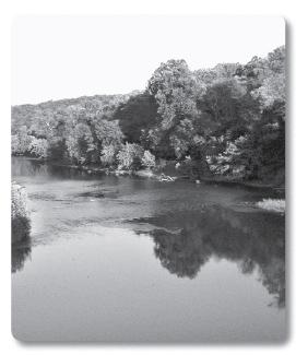
The Meramec River almost became Meramec Lake. The U.S. Army Corps of Engineers had already begun construction of a dam on the Meramec River when a public vote in 1978 resulted in deauthorization of the project. Today, the Meramec still flows freely, and several miles of the scenic river and its wooded banks are preserved in the park, providing a haven for abundant wildlife. The Meramec contains the greatest variety of aquatic life in Missouri. Exhibits in the visitor center interpret this healthy and diverse habitat.
Missouri has over 6,000 caves, and 47 of these are hidden within Meramec’s expansive forests-more than in any other park in the state. Naturalist-led tours of the largest and most spectacular cave in the park, Fisher Cave, offer the park visitor adventure, outstanding cave scenery, and insight into how caves and calcite deposits are formed. The 90-minute tours are given four times daily during the summer for a small fee.
Directions: From Sullivan, travel 3.2 miles south on Highway 185 to the park entrance.
Hours Open: The park is open year-round. The front gate is open from 7:00 a.m. to 10:00 p.m. daily from April through October and from 7:00 a.m. to 9:00 p.m. daily from November through March. The visitor center is closed on Thanksgiving, Christmas Day, and New Year’s Day.
Facilities: The park offers a visitor center that includes a 3,500-gallon aquarium, a large campground, an outdoor amphitheater for interpretive programs, cabins, a motel, a convention center, a grill, a boat ramp, picnic areas and shelters, play areas, a store, and canoe and raft rentals.
Permits and Rules: Do not enter any cave without first contacting the visitor center. Some caves require a permit to enter. Pets must always be leashed. Some campsites are reservable, although others are not.
For Further Information: Meramec State Park, 115 Meramec Park Drive, Sullivan, MO 63080; 573-468-6072 (visitor center) or 573-468-6519 (cabin and canoe rental).
Deer Hollow Trail (1.8 miles). This linear trail, which connects the dining lodge to Fisher Cave, is a good trail to see blooming dogwood trees in late April, fall colors in early October, and white-tailed deer all year long.
Walking Fern Trail (.5 mile). This trail takes you next to Indian Cave, through a lush forest, next to a boulder covered with walking ferns, and up onto a dry upland forest. The trail begins and ends at Fisher Cave.
River Trail (.8 mile). This loop trail begins at the southern end of the campground and winds along a slough of the Meramec River.
I had been sitting on a large rock on the glade for about 15 minutes before I noticed a rather large, coiled eastern coachwhip snake about 6 feet away. I admired its braided brown and tan coloring before I crept slowly away, leaving the snake to its morning reptilian business.
Caution: Do not enter any cave without contacting the visitor center for a review of cave regulations and a check for the possibility of a flash flood.
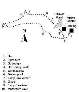
Trail Directions: Before or after your hike, be sure to see the exhibits and the park slide show in the visitor center. Park in the lot for the visitor center and begin the trail at the trailhead [1] at the southeast end of the lot. Turn right at the intersection at .08 mi. [2], and soon you are hiking under the whispering branches of a shortleaf pine grove. Ignore the spur to the right at .13 mi. [3] and go straight, looking for signs of beaver on nearby trees. Elm Spring Creek riffles along the trail at .17 mi. [4]. Look for beaver here, as well as at the Beaver Pond behind the visitor center. October is the best time to watch for beaver, when their preparations for winter make the nocturnal rodents more active during the day.
Just after you cross a small drainage at .22 mi. [5], you find a wet meadow on your left. The stream flowing out of Mushroom Cave (passed later on the trail) keeps this area eternally moist, providing a good habitat for burrowing devil crayfish. You may see their mud chimneys near the trail here. Stop by the stream pool at .27 mi. [6] and look for camouflaged sculpin fish lying on the bottom and agile water striders skating across the top. You also find watercress here and a good patch of spearmint.
Just before you cross a wooden bridge at .44 mi., you’ll see an entrance to Camp Cave [7]. More accurately, this is an exit to Camp Cave because the water flowing out of it comes from another opening to the cave (encountered later), which acts as a surface stream drain. This situation is known as stream piracy. Cross the bridge to continue. Climb the hill and find the continuity of the forest broken by a beautiful glade [8] (.53 mi.). Layers of the sedimentary dolomite created three levels of the glade, making a three-tiered minidesert, resplendent with prairie dock, shooting star, Indian paintbrush, and purple coneflower.
At .67 mi. [9], stand at the top of the wooden switchbacks and look down the ravine. This is part of a collapsed cave passage. At the bottom of the switchbacks is the inlet entrance to Camp Cave. Hike under the canopy of black walnut, white oak, pawpaw, and dogwood trees on your way to yet another cave opening. Find the yawning maw of Mushroom Cave at 1.05 mi. [10], the site of several commercial mushroom farming operations in the early 1900s. Today, wild hydrangea flourish near the cave’s outflowing stream, which is always cool enough to refresh hot feet-even in the middle of summer. The minicanyon just across the trail is another section of an ancient, collapsed passageway. On your way back, go straight at the intersection at [2] to return to the trailhead.
Rocky Fork Lakes Conservation Area, 6.9 miles south of the Pinnacles, includes 2,200 acres of forests, old fields, grassland, and savanna. The area has 20 fishing ponds, including 52-acre Rocky Fork Lake, which has a boat ramp. Activities include fishing, hunting, hiking, and bird-watching. The area has a wheelchair-accessible fishing dock and a firearms shooting range. The area is 7 miles north of Columbia, off Highway 63, on Peabody Road. For more information, call 573-445-3882.
Finger Lakes State Park is one of two state parks that allows off-road motorcycling and ATV use. The 1,129-acre park is reclaimed strip-mine land, and the old strip pits offer swimming, fishing, and canoeing. A picnic area and campground are available. Finger Lakes is also just south of the Pinnacles, off Highway 63, on Peabody Road. For more information, call 573-443-5315.
It was in water, in the form of a shallow sea, where sediments formed this Burlington limestone around 290 million years ago. And it is water, in the form of streams, rain, and ice, that is wearing down the pinnacles today, reclaiming the rock and its embedded ocean animals.
Caution: This trail is not for the acrophobic, the fainthearted, or young children. Hikers must negotiate narrow, steep, and precipitous passages on the pinnacles.
Trail Directions: Start the trail at the trailhead sign [1] at the east end of the parking lot. Go downhill toward Silver Fork Creek. At .03 mi. [2], turn right at the small picnic shelter on your left and follow the trail as it parallels the creek. Look at the rugged peaks just across the stream. Those are the pinnacles on which you will soon be hiking! Go straight at the trail intersection at .11 mi. [3]. Go straight at the spur on your right at .19 mi. [4], which leads to a small picnic shelter. Just after crossing a wooden bridge and a rock outcrop on your right, go straight at the intersection at .24 mi. [5]. You are now on a short spur that dead-ends at a surprise at .29 mi. [6]-a shelter bluff, about 40 feet deep and 125 feet long, cut into the limestone bluff by the eroding power of Silver Fork Creek. The next geologic oddity that you encounter will be about 75 feet higher!
Return to the intersection at [5], where you turn right and find a shallow spot to cross the stream. Climb the bank on the opposite side and turn left. Bear left at the fork in the trail at .51 mi. [7], where you begin your climb. The views keep getting better as you continue the rugged and narrow trail on the spine of the pinnacles. You pass an eastern red cedar tree with a twisted trunk that seems to be growing straight out of the rock. As you pick your way carefully over the peaks, drink in the vistas. Then, if you zoom in for a close look at the rocks, you’ll find that they are loaded with fossils. Many of these fossil disks are the remains of invertebrate ocean animals known as crinoids. The crinoid, by the way, is Missouri’s state fossil.
This is an excerpt from Hiking Missouri, Second Edition.
|
|